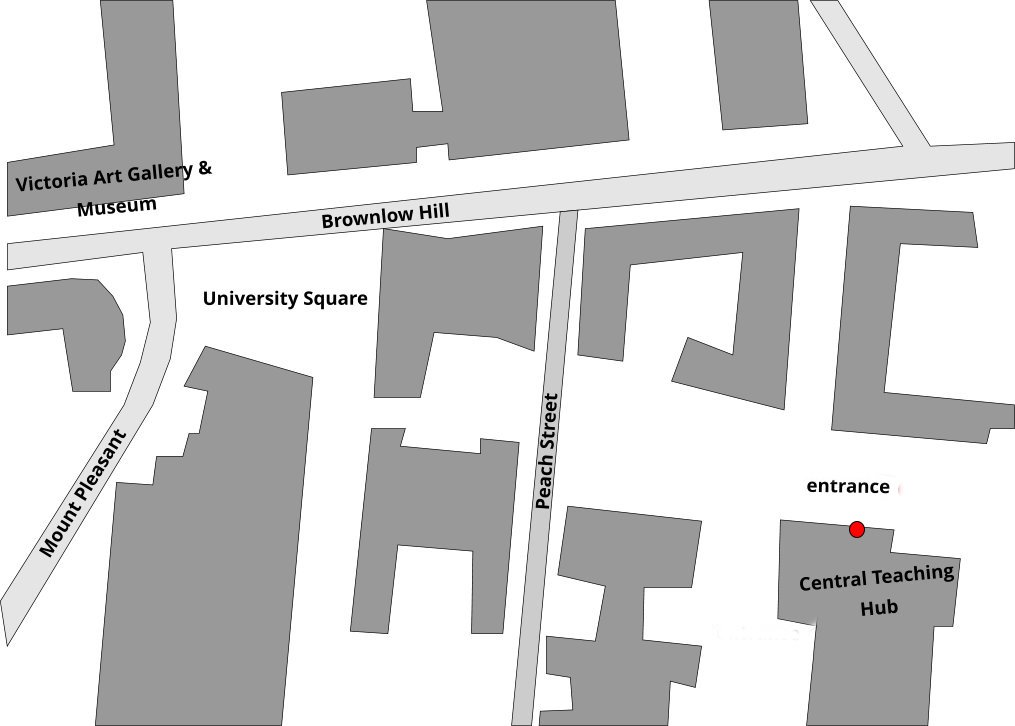
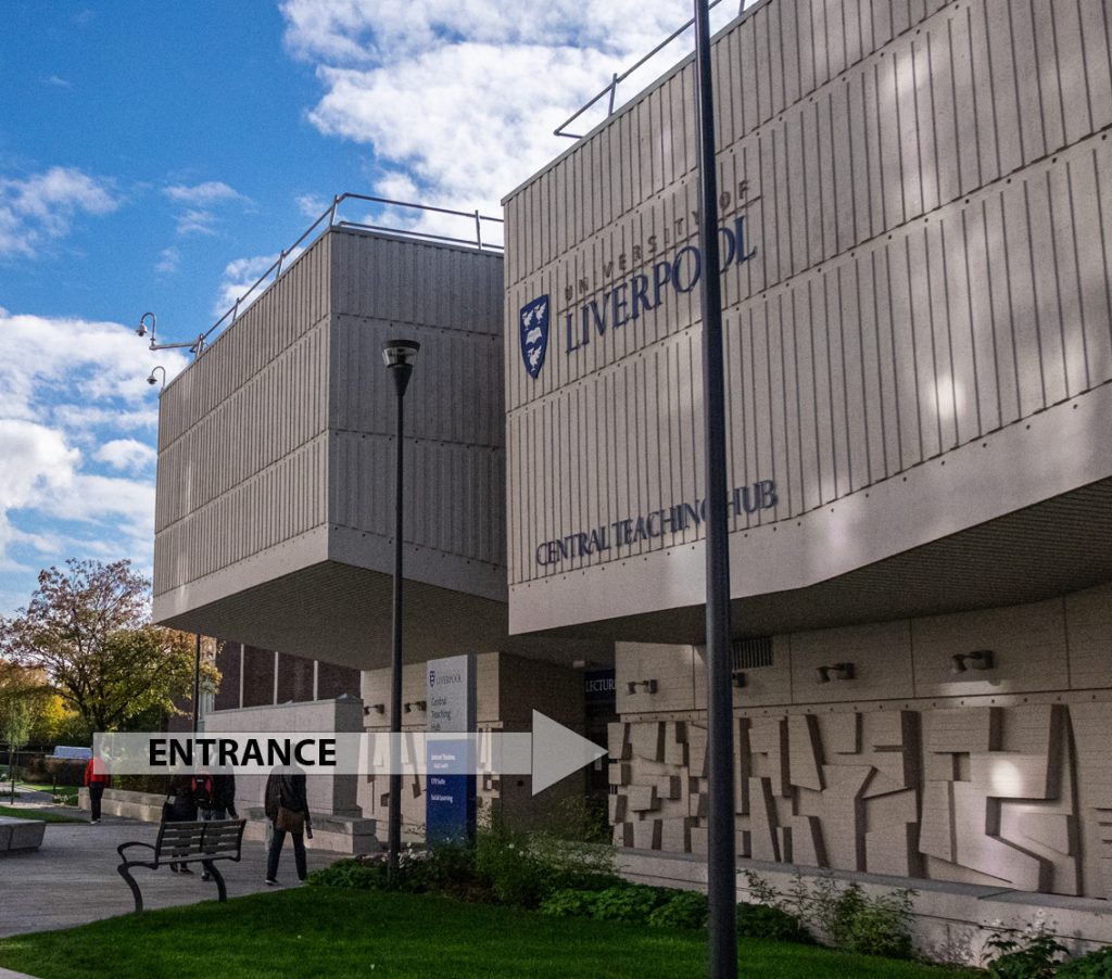
Indoor meetings


2024-2025


All talks for 2024-25 will take place at the Central Teaching Hub of the University of Liverpool, Lecture Theatre C, but please check the LGS Newsletter to make sure there has not been a change of room for a particular meeting. Entrance will be via the main door.

Talks will start at 7.30pm and finish by 9.00pm.

Location map for the Central Teaching Hub
Front of the Central Teaching Hub

2025


Feb. 4th

Dr Kostas Kiriakoulakis, Liverpool John Moores University

Deep Sea Canyons

Submarine canyons are deep, steep-sided underwater valleys cutting into continental shelves and slopes, often extending from shorelines to abyssal depths. These large and widespread (>9,000 globally) geomorphic features are typically formed by a combination of tectonic activity and gravity flows, most commonly turbidity currents. Their morphology is also influenced by (internal) tides, ocean circulation and sediment supply; recent evidence suggests that anthropogenic activities may add to these. They serve as important conduits for the transport of natural and anthropogenic material to the deep ocean, often forming large deep-sea fans, and many of them host diverse ecosystems due to their complex physical and biogeochemical conditions. Submarine canyons can modify energy dissipation in their vicinity, occasionally affecting manmade installations, and they seem to influence marine ecosystem functions, such as primary productivity and carbon burial, and related ecosystem services such as fisheries and bioprospecting. Recent work has clearly shown that many of these features have been impacted by human activities, in the form of habitat destruction, pollution, ocean acidification and climate change. Understanding the functions, role and threats of submarine canyons remains a critical, yet undeveloped, area of marine research, with implications for broader ocean science and management.


Feb. 18th

Professor Tim Wright, University of Leeds

Satellite monitoring of our hazardous planet.

Nearly 1 million people have died as a result of earthquakes in the last 20 years, and hundreds of thousands of people have been evacuated from their homes due to volcanic activity. Across the planet, natural hazards continue to turn into disasters. In this talk, Prof Tim Wright will highlight the work of scientists in the UK’s Centre for the Observation and Modelling of Earthquakes, Tectonics and Volcanoes (COMET), who are at the forefront of international efforts to observe and monitor our hazardous planet from space. He will explain how satellites orbiting 100s of km above the earth can map movements from tectonics and volcanism with millimetre accuracy. And he will discuss how this critical information is helping decision makers around the world prepare for and quickly respond to earthquakes and eruptions.


Mar. 4th

Doctor Alastair Baird

The geological structure of central/northern Snowdonia (Eryri):

Significant modifications to the status quo.

As a result of extensive mapping and research by BGS geologists and affiliated geoscientists from the early 1970’s to the end of the Millenium, a complex story of Caradocian (Late Ordovician) volcanic and volcanoclastic structures and transtensional back-arc basins, followed by Acadian (Late Caledonian) deformation and metamorphism, has been generated and widely published. Brief summaries of this work appear in “The Geology of England and Wales (2006)” and “Geological History of Britain and Ireland (2012)”.

The presenter of this talk published a short paper on the structure of the Ogwen / Idwal area of Snowdonia in 1999. More recently, after Covid, having retired to north Wales, and whilst contemplating leading a Snowdonia field trip for another local Geol. Ass., the author joined a Liverpool Geol. Soc. trip to the same area. Whilst doing some preparatory reading for that trip, it became obvious that much of the published structural analysis for the region was illogical, unjustified and often simply nonsense. This realisation has resulted in him resuming geological fieldwork in the area.

In this talk, the current “orthodox” view (= the status quo) will be summarised before a fieldwork-justified alternative interpretation is presented. In this revision, the nature of Caradocian caldera structures, Caradocian transtensional “basin bounding” faults, the Acadian structural evolution including the cleavage-transected folds, polyphase deformation and the formation of the regional arcuate fold structure (= orocline) in north Wales will be discussed.


Mar. 11th

Doctor Maggie Williams, University of Liverpool

Practical Session: Ice ablation

Glaciers are large persistent bodies of ice that form where the accumulation of snow exceeds its ablation (i.e. melting) over many years. The process of snow becoming ice begins as the air gaps between snow crystals are squeezed out and filled in due to a combination the weight of subsequent snowfall and the refreezing of meltwater within the snowpack. This compacted and refrozen snow is called firn and it still contains pore spaces. Over time as it is buried further it is compacted even more so that any air left in the ice is compressed into bubbles, the density of the firn increases, and glacier ice is formed.


Mar. 18th

Annual Dinner

Please note that the image used may not be the actual venue.


Verified by MonsterInsights